Themes and Activities
Forecasting & Remote Sensing
Ocean circulation models continue to be incredibly important for a number of applications from the open ocean to populated coastal areas.
The modeling team at COMIT is working on a number of improvements to their Tampa Bay Coastal Ocean Model (TBCOM) and West Florida Coastal Ocean Model (WFCOM). This work has direct, immediate impact on nowcast and forecast products that a number of agencies and organizations rely upon on a daily basis.
Our modeling experts have also been working closely with the mapping experts on the COMIT team to improve upon and assess bathymetric and topographic influence on the coastal ocean circulation.
Some of the current projects related to this theme are summarized below:

Moored buoy platforms at the USF College of Marine Science waterfront
WFCOM (Coastal Model) Improvements
The modeling team started working on modifying their West Florida Coastal Ocean Model (WFCOM) to leverage the Global HYCOM boundary forcing as opposed to the Gulf of Mexico HYCOM option. Decommissioning the use of the latter model was in response to its limited availability of boundary forcing.
However – the Global HYCOM does not include any tidal components so this modification necessitated an enormous effort to successfully complete. The modeling team used a barotropic tidal model to generate tides which were subsequently incorporated into the WFCOM. The hard work paid off and the WFCOM, as well as the Tampa Bay Coastal Ocean Model (TBCOM), both resumed normal automated nowcast/forecast runs as of late last year (2023).
Model simulation results (including currents, temperature, and salinity, sea level, and particle trajectories are made publicly available on the web as maps. These can be used immediately for quick reference of the circulation patterns.
Impact of Bathymetry on Coastal Circulation
Due to their shallow nature, the circulation models developed for estuaries and coastal areas tend to be sensitive to bathymetric changes. To better quantify and understand the impact of bathymetric changes on sea level and current predictions in such environments, the modeling team used their TBCOM model to investigate how forcing at the mouth of Tampa Bay using existing bathymetry and bathymetry that had been purposefully altered affected hydrodynamic response.
The simulated sea level, amplitude and phase of the semi-diurnal tides, and associated currents were compared between the two experiments. Significant changes in water level (up to +/-10 cm) and current velocities (up to 20 cm/s) were found in the shallow peripheral areas.
The results of this sensitivity test confirm that it is imperative to use accurate bathymetric data underpinning these models – meaning even if bathymetric data exist in a coastal area, unless it was collected relatively recently it may be sub-optimal.
Not only is accurate bathymetry important for water level and currents, but the reliability of scalar variable estimates is diluted when water depths are incorrect. Thus, it is not possible to accurately assess salinity, or other ecologically important properties, if the underlying water depth itself is not accurately known.
This collaborative work has been published as a peer-reviewed journal paper which provides further detail and discussion: Chen, J., Liu, Y., Weisberg, R. H., Murawski, S.A., Gilbert, S., Naar, D., Zheng, L., Hommeyer, M., Dietrick, C., Luther, M., Hapke, C., Meyers, E., Moghimi, S., Allen, C., Tang, L., Khazaei, B., Pe’eri, S., & Wang, P. (2023) Hydrodynamic response to bathymetric changes in Tampa Bay, Florida. Deep Sea Research II: Topical Studies in Oceanography, 212, 105344. https://doi.org/10.1016/j.dsr2.2023.105344.
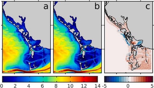
Original Bathymetry (a), Altered Bathymetry (b), and the difference between the two datasets in meters (c)
Nowcasts and Forecasts for Navigation
Precise sea level predictions increase the likelihood of safe vessel navigation and operation, especially in coastal and estuarine where mariners contend with shallow bathymetries, narrow channels, and other hazards.
The modeling team behind the Tampa Bay Coastal Ocean Model (TBCOM) are working with the Tampa Bay Port Authority to discuss integrating coastal ocean models into their workflow.
To better understand what’s needed to achieve this goal, our modeling team used TBCOM to simulate hindcast sea levels at five tide gauge locations around Tampa Bay, then compared these with simulations with actual observations. For the 1-day and 2-day forecasts, there was excellent agreement in both the amplitude and phase at all five stations. The offsets between the forecast and observed sea levels only began to increase at the 3-day point due to deviations in forecasted and measured winds. Despite an increase in error by the 3-day mark, general agreement remained between forecasted and measured sea levels.
A full explanation of this work and discussion of its results are documented in the following peer-reviewed journal paper: Chen, J., Weisberg, R. H., Liu, Y., & Zheng, L. (2023). Hillsborough bay inflow modification study: An application of the Tampa Bay Coastal Ocean Model. Estuarine, Coastal and Shelf Science, 281-108213. https://doi.org/10.1016/j.ecss.2023.108213.
Improved Storm Surge Simulations
Storm surge simulations based on an “Ian-like” hurricane
NOAA uses the Sea, Lake and Overland Surges from Hurricanes (SLOSH) model to provide storm surge guidance for all U.S. coastal regions. SLOSH generally performs very well but its storm surge results tend towards the “worst-case” scenario and typically do not provide specific information about the landfall location.
Hurricane Ian made landfall near Ft. Myers, Florida as a Category 4 storm on September 28, 2022. It was the deadliest hurricane to strike the State of Florida since the 1935 Labor Day hurricane and caused enormous economic losses. The TBCOM nowcast/forecast system successfully predicted the sea level evolution within Tampa Bay during this period. Being that Ian was first expected to strike near Tampa Bay, our researchers wanted to address the question of what may have happened had Ian not altered its course. This question was explored using TBCOM with Ian’s path translated northwest from its actual path, forcing landfall in Tampa Bay region.
Numerical experiments with a modified Ian path suggest that there would have been substantial coastal inundation over the low-lying areas of the Tampa Bay vicinity.
This work is ongoing and will be completed in late-2024.
TBCOM-Flooding Hindcast: Hurricane Idalia Storm Surge
In the Tampa Bay area, the threat of inundation during hurricanes is a significant concern due to the region’s low-lying topography. Though it did not make direct landfall, Hurricane Idalia recently led to the highest recorded water levels in the Tampa Bay area. This resulted in flooding in low-lying waterfront areas, primarily caused by the storm surge. The modeling team is using the data from this weather event to expand the TBCOM model grid to land area and build a new TBCOM-flooding model.
This work is ongoing and will be completed in late-2024.