Me at my desk at CMS, creating digital ecosystems!
Written by: Bea Combs-Hintze, PhD student with Drs. David Naar & Steve Murawski.
It’s all about Balance – in life, and in modeling
I am expecting my first child at the end of the month. (Deep breaths.)
Life these days is about seeking balance: between work, research, self-care, and motherhood preparations. I take comfort in the fact that as an ecological modeler, I am no stranger to seeking balance. Any change to an ecosystem may influence its overall energy or mass balance, and/or impact other variables within the system. We build and use computer models to replicate and better understand real-world systems that are complex and difficult to observe directly.
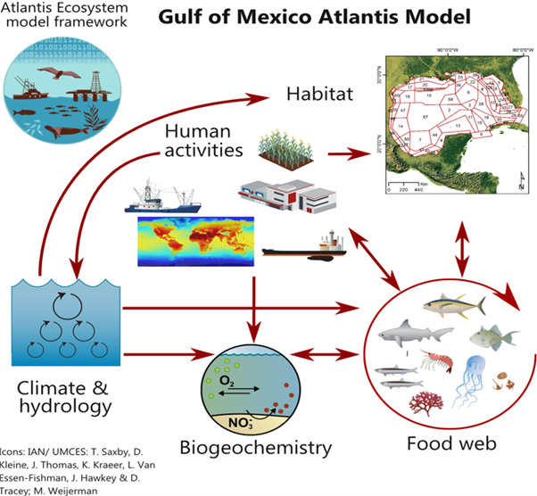
The ecological model I work with is called Atlantis. It is used in marine ecosystem management and takes into account all parts of a marine ecosystem: biophysical, economic, and social. It’s powerful, but not perfect.
At the core of Atlantis is an ability to track nutrient flows through the main biological groups in the system. The key ecological processes modelled are consumption, production, waste production, migration, predation, recruitment, mortality, and habitat dependency. So basically, who’s dying, how many organisms are reproducing, what’s the health of the organisms, is there enough food for everyone, and so on. All of these parts need to be based on the balance observed in the true system.

Graphic representation of the Atlantis Gulf of Mexico Model – which is computer magic + math, capable of representing the various parts of the marine ecosystem.
Unfortunately, habitat tends to be underrepresented in this model. Habitat surveys are done to fit specific needs and may be conducted across different time and space scales. This becomes a problem when modeling large-scale ecosystem changes.
That’s why I’m focused on trying to improve how the model incorporates seagrass meadows. Seagrass provides food and habitat to marine and human communities, protects coastlines from erosion, and is a crucial blue carbon sink. The recent (and inaugural) mapping survey by the COMIT team — the Tampa Bay Bathymetry Experiment (TBBEx) project — used a combination of technologies to generate high-resolution maps of shallow coastal areas, which is where seagrass lives.
Go team COMIT!
These new maps from TBBEx and COMIT’s future endeavors will give us a closer look at how storms will impact sea level for coastal communities, help with shipping and boating dredging planning, and help further define habitat for macrofauna like the Florida manatee and a variety of marine fish species. They’re also going to help me better characterize seagrass beds and incorporate those in the Atlantis model.
The technologies used in the COMIT survey included multibeam sonar (sound wave) sensors on an uncrewed surface vessel (USV), which offered a detailed look at the bathymetry in some of the deeper inshore areas, and new laser detection and ranging (LiDAR) data gathered by sensors on a plane which covered the shallower inshore areas.

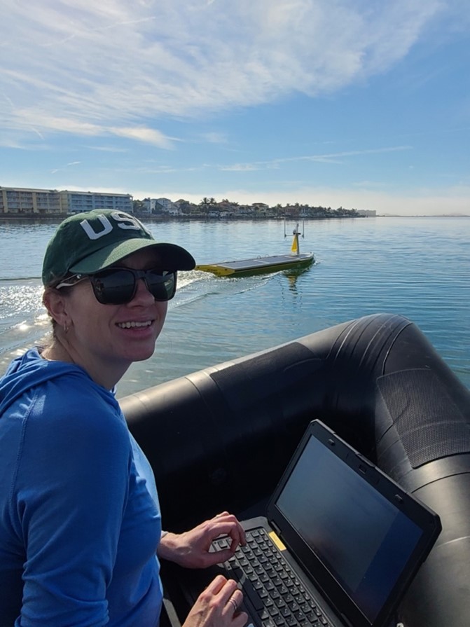
Me on the chase boat last Fall, part of the COMIT field testing of the USV’s ability to map inshore bathymetry.
With this new high-resolution data in our hands, we can begin to get a clearer picture of the bottom of Tampa Bay, and in my case, the habitats that reside there.
The magic happens when this information is combined with existing optical surveys (such as from divers, boats, or plane photos) and satellite imagery — which can distinguish between the chlorophyll from phytoplankton and other types of vegetation like seagrass. This info can “ground-truth” or verify our sonic and laser measurements.
All of these technologies — satellites, planes, and USVs – can often cover larger areas more efficiently than what we can do from traditional research vessels, as well as reach the nooks and crannies that these ships can’t safely navigate. They also complement each other; LiDAR data gives us the details of the bottom – how rugged it is, what the slope is like, and more. But it only works well in shallower water where the laser can penetrate to the seafloor. Multibeam sonar is really good at getting accurate bathymetry or depth information and can be used in much greater depth ranges, but it’s incredibly inefficient at extremely shallow depths. Combining the backscatter data from both LiDAR and multibeam with satellite images help us discern if what we are seeing on the bottom is seagrass or rock or mud…
As I look around at my habitat these days, I see the structure of my ecosystem here at home changing dramatically: a bassinet in front of the bookshelf, a jogging stroller blocking the table. I find myself wishing I could run simulations on my life to see how the future of my research will look with a baby on my hip, but I guess some things are best left to surprise. I trust that I will adapt to my new world relatively quickly.
I am much more concerned about how changes to our marine habitat will influence the life of my child. Will seagrass loss cause faster coastal erosion? Will algae blooms shade the seafloor and cause seagrass die-offs that ultimately impact fisheries? How will seagrass migrate with rising sea level? These are the types of questions that ecosystem models are poised to answer, as long as they are balanced and represented well with data. We’ll keep doing our part to ensure our science can help make better policy and management decisions moving forward.

P.S. Since this article has been written baby Teigan Leo Hintze has landed on Earth!

Recent Comments