 DOWNLOAD up-to-date GeoTIFFs of areas that have been mapped by USF/C-SCAMP as of November 2018!
Learn how to import GeoTIFFs into Google Earth here.
One of our first aims when starting this project was to make sure that we do not duplicate any mapping efforts that have already been accomplished by others. To do this, we began combing various online databases for anything related to mapping activities on the West Florida Shelf (WFS). We also coordinated with the Florida Fish and Wildlife Research Institute (FWRI) as well as the NOAA Southeast Fisheries Science Center (SEFSC) and NOAA Panama City Lab, as each had mapping datasets of their own; FWRI and the NOAA Panama City Lab have been using sidescan sonar to map areas throughout the WFS for several years and the SEFSC has in recent years begun mapping small patches in the eastern Gulf using multibeam sonar (Simrad ME-70).
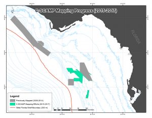
Below is a map which shows the footprints for all large-scale multibeam bathymetry mapping efforts located on the northern WFS. All of these areas have bathymetry available at a grid size of 10×10-meter or less (lower value = greater detail).

